
The National Weather Service estimated that Hurricane Florence dumped almost 8 trillion gallons of rain on North Carolina in September 2018 resulting in catastrophic flooding across the state. 1 A NASA satellite tracked the flooding as shown in these remarkable images.
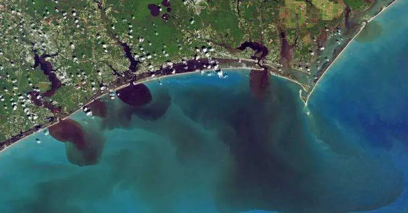
The first image above shows the photograph taken by the Landsat 8 earth observation satellite as viewed in natural color which “reveals how soils, sediments, decaying leaves, pollution, and other debris have discolored the water in the swollen rivers, bays, estuaries, and the nearshore ocean.” 1
The second image below, rendered by NASA data visualizer Joshua Stevens, “combines visible and infrared data from Landsat to reveal the amount of colored dissolved organic matter (CDOM) in those waterways. Organic matter—such as leaves, roots, or bark—contain pigments and chemicals (such as tannins) that can color the water when they dissolve. Depending on the amount of dissolved particles, the water in natural-color imagery can appear blue, green, yellow, or brown as the CDOM concentration increases.” 1 You can read a fascinating Twitter exchange about the images with Dr. Stevens here. 2

The impact from the CDOM raises concerns because the coastal waters that normally provide nourishment to a wide range of fish, crustaceans, and crabs suddenly become toxic from the cloudy sediments. The nutrients actually change the biogeochemistry of coastal ecosystems creating dead zones that result in fish kills. 3
The research community has been documenting ongoing impact of hurricanes on the Atlantic Ocean and its watersheds. Here are just a few examples of devastation to inhabitants of watersheds and coastal waters from notable hurricanes:
Estuary waters are darkened by particulate matter which decreases phytoplankton productivity which is a vital part of the food chain for ocean life. Hurricane Andrew in 1992 darkened the Everglades. Hurricane Fran in 1996 was shown to limit light reaching available to phytoplankton in the Cape Fear Estuary. 4
The video below illustrates how hurricanes flood waterways, exposing humans and wildlife to harmful toxins and bacteria.
Hurricanes cause churning up of mud and organic matter from the floor of bays and wetlands which decreases oxygen in the water. Hurricane Donna in 1960 resulted in a large kill of fish and invertebrates in the Everglades and Florida Bay. Hurricane Agnes in 1972 flooded the Chesapeake Bay with outflows of rainwater which created low dissolved oxygen levels. Hurricane Hugo in 1989 poured heavy concentrations of debris and leaf litter along with overflowing septic and sewer systems that resulted in reduced oxygen levels in the water of Charleston Harbor and large fish kills. 4

The high prevalence of indoor concentrated animal operations (CAOs) for hogs and poultry in North Carolina brings the practice of diverting huge quantities of animal urine and feces to large open lagoons where the waste is supposed to breakdown before it is sprayed on surrounding fields. Unprecedented flooding from Hurricane Florence breached waste lagoons and inundated the Cape Fear floodplain. It is estimated that the failure of just two lagoons emptied 7 million gallons of untreated hog feces into surrounding waterways with its eventual destination being the Atlantic. 5
You can read a first-hand local account from the time as well as video showing NASA’s satellite-tracked flooding in the Carolinas following this devastating hurricane. Its images show dark, polluted water flowing from rivers into the Atlantic Ocean as shared by The Charlotte Observer here. 6
References
1Patel K and Carlowicz M. A Broad View of Flooding in the Carolinas. 22 September 2018. NASA Earth Observatory. https://earthobservatory.nasa.gov/images/92786/a-broad-view-of-flooding-in-the-carolinas
2Stevens J. Twitter. 21 September 2018. https://twitter.com/jscarto/status/1043172773542207488
3National Science Foundation. Two Decades of Hurricanes Change Coastal Ecosystems: Increase Algae Blooms, Fish Kills, Dead Zones. 2 May 2018. https://www.nsf.gov/discoveries/disc_summ.jsp?cntn_id=245304&org=NSF&from=news
4Malin MA et al. Hurricane Effects on Water Quality and Benthos in the Cape Fear Watershed: Natural and Anthropogenic Impacts. Ecological Applications. 1999; 9(1):350-362. https://www.jstor.org/stable/2641190?seq=1
5Davis W. Overflowing Hog Lagoons Raise Environmental Concerns in North Carolina. NPR. 22 September 2018. https://www.npr.org/2018/09/22/650698240/hurricane-s-aftermath-floods-hog-lagoons-in-north-carolina
6Bennett A. NASA Can See Dark, Polluted Carolina Rivers Spilling into the Ocean from Space. 24 September 2018. The Charlotte Observer. https://www.charlotteobserver.com/news/local/article218934685.html?fbclid=IwAR1DUJaqELC7vBF9n7TLfleugIAW8DKNUqiAwl_wNp9Cuw0z8B1vmvGTfuA
NASA image source: https://eoimages.gsfc.nasa.gov/images/imagerecords/92000/92786/northcarolina_oli_2018262_cdom.png
North Carolina National Guard image source: https://www.flickr.com/photos/ncngpao/44792431821/in/photostream/

This Site Was Inspired By An Interest in Protecting the Environment:
We had the privilege and joy of learning from Dr. Charlie Stine who instilled a love for the natural world through incredible field trips with the Johns Hopkins Odyssey Certificate program in Environmental Studies. At the time, the program was endorsed by the Maryland Department of Natural Resources. Sadly, after Dr. Stine retired, the program was phased out. We hope that we honor his legacy by shining a bright light on environmental issues and sharing good news about the success of various conservation programs when possible.
